Exercise 5: Adding a Layer
GeoMoose treats layers for MapServer the same as it does OGC WMS layers. This requires some special treatment of the MapServer Mapfile.
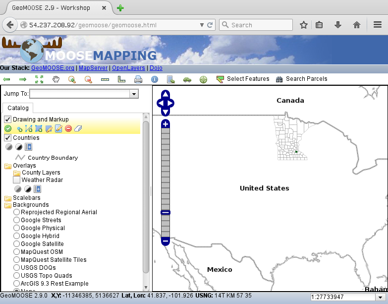
This exercise will add the countries layer from the Natural Earth dataset. We will need to create a Mapfile to tell MapServer how to render the layer. Then we will add that layer to the catalog. Later, we will intentionally break the layer to demonstrate how to troubleshoot typical problems.
Getting The New Data
Go to the
/srv/geomoose/mapsdirectory:cd /srv/geomoose/maps
Create a new directory for the workshop:
mkdir workshop
cd workshop
Download our new data:
wget https://github.com/geomoose/geomoose-docs/raw/umgeocon/source/workshops/umgeocon2016/ex5-data.zip
wget is a program for downloading files from web servers. Its name comes from “WWW” and “get”. This will download the ex5-data.zip file to the current directory.
Unzip it! There is no need for a graphical unzip program! We can use the command line:
unzip ex5-data.zip
Oh, no! That didn’t work! Not all utilities will be installed on cloud servers. Ubuntu is helpful in letting us know what to install. To unzip the file we will first need to do this:
sudo apt-get install unzip
Now it should work fine.:
unzip ex5-data.zip
Working with the Data
The ZIP file contained a new ex5-data directory. In that directory, there is a full set of files for the natural earth country Shapefile. But there is an additional MapServer MapFile as well natural_earth.map. The contents are included here for reference.:
MAP
      NAME 'all'
      SIZE 800 650
      STATUS ON
      EXTENT -20037508.34 -20037508.34 20037508.34 20037508.34
      UNITS METERS

      INCLUDE "../../geomoose_globals.map"

      WEB
              METADATA
                      'ows_title' 'Countries'
                      'ows_srs' 'EPSG:26915 EPSG:4326 EPSG:3857'
                      'wms_enable_request' '*'
              END
      END

      PROJECTION
              'init=epsg:3857'
      END

      LEGEND
              STATUS ON
              LABEL
                      TYPE TRUETYPE
                      FONT vera_sans
                      SIZE 8
                      COLOR 0 0 0
              END
      END

      LAYER
              NAME 'countries'
              DATA 'ne_10m_admin_0_countries'
              STATUS ON
              TYPE POLYGON
              MINSCALE 1000
              PROJECTION
                      "init=epsg:4326"
              END
              LABELITEM 'NAME'
              CLASS
                      NAME "Country Boundary"
                      STYLE
                              SYMBOL 'circle'
                              SIZE 1
                              OUTLINECOLOR 50 50 50
                      END
                      STYLE
                              SYMBOL 'circle'
                              SIZE 3
                              OUTLINECOLOR 210 210 210
                      END
                      LABEL
                              TYPE TRUETYPE
                              FONT vera_sans-bold
                              MINSIZE 8
                              SIZE 10
                              MAXSIZE 12
                              COLOR 0 0 0
                              OUTLINECOLOR 232 232 232
                              BUFFER 4
                      END
              END
      END
END ## end Map
Adding the layer to the Mapbook
Open the mapbook in a
nano:nano /srv/geomoose/conf/mapbook.xml
Add the natural-earth map-source above the
parcelsmap-source. A map-source tells GeoMOOSE how to connect to a data layer. Note: the order of the map-sources controls the default draw order of the layers.:<map-source name="natural_earth" type="mapserver" queryable="true"> <file>./workshop/ex5-data/natural_earth.map</file> <layer name="countries"/> <param name="TRANSPARENT" value="true"/> </map-source>
Add the layer to the catalog section.:
<layer title="Countries" src="natural_earth/countries" status="on"/>